|
|
 |
|
|
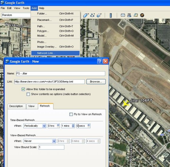
You can Track my Flight Simulator Flights
LIVE
using Google Earth. All you need to do is add a new network link
to the tracking data on my website in GE. The Link for my tracking data
is:
http://bearclaw.rexx.com/jitar.kml
The link is updated every 60 seconds while I am in flight.
My position is shown as an aircraft icon and will display my Altitude
and Ground Speed. If I have a Flight
Plan, it will be
shown on the map. Clicking on the icon for my aircraft will show you
information about the aircraft I am flying, and a picture of it.
To Locate my aircraft, you can double click on the link in the sidebar
of GE.
(Most often I can also be found at Zamperini Field in Torrance
California. That is my "Home Base" in Flight Simulator, and where my
aircraft are parked.)

Icons
used on the Map
|

|
My
Current
Location - Updated every 60 seconds.
The tag next to the aircraft icon shows My current call sign (Which
Aircraft I am using), My Altitude (Feet above sea level, or if above
QNH as Flight Level
(which is x100 Feet (FL180 = 18,000 feet) and My Ground speed. The
(Yellow) Line in front of my aircraft is a prediction of my course for
the next 60 seconds
|

|
Other
Aircraft
- Only IVAO aircraft within 25 nm of me are shown.
|

|
An
Airport.
(Only those in my current Flight Plan are shown)
|

|
A VOR
Transmitter [Radio Navigation Beacon] that I am using to navigate with.
(For Detailed description see "VHF
Omnidirectional Range" in Wikipedia) |

|
An NDB
[Radio
Navigation Beacon] that I am using to navigate with. (For Detailed
description see "Non
Directional Beacon" in Wikipedia)
|

|
The
Orange
Line shows the path of My Flight Plan.
|

|
The
White Line
shows the path I have recently flown.
|
For
anyone
interested in how this is done: I use an add-on in flight simulator
called FSEarth which outputs the files needed for Google Earth. A
Program I wrote called FTPCOPY is used to post the data onto my
website. (The FTPCOPY Program is available as shareware on this
website, see the MISC page of My Software.)
|
|
|
 |
|
